February 16, 2011

Newton Lane to Black Bridge

We paddled the Newton Lane to Black Bridge on February 15, 2011.  Air temperature was in the mid-60's and water temperature was 48 degrees.  Skies were clear with no wind.

John P. and Josh W. put in the water at 11:20 am and arrived at the take out at 2 pm.  The GPS track log says the trip was 5.85 miles.  Our moving average speed was 3.0 miles per hours and our overall average speed was 2.2 miles per hour.  The GPS indicates we were moving for one hour and 56 minutes and stopped for 44 minutes.

Not far below Newton Lane, we encountered the formidable Verde Ditch Diversion Dam.  We hadn't been to this spot since March 2007.  The diversion's appearance and character had changed.  At first we thought the ditch company was already diverting water as 100% of the river entered the ditch itself with an obvious current flow downstream in the ditch.  Perhaps less than one percent of the river flow was trickling through what is normally considered to be the diversion structure.

We were very concerned and put our shuttle driver on "hold" via cell phone.  We then called Chip N. to confirm his information that the ditch wasn't going to divert the river until February 18 at the earliest.  Chip reassured us about the date.  We walked downstream and realized that some flow was going back into the river via a breach in the river left sidewall of the crude ditch structure.  We assessed this flow and determined it would be sufficient to continue the day's paddle.

The portage was rather difficult but didn't take too long.  The first part of the portage is over rough and jagged concrete remnants.  Here, paddlers must raise their boat and carefully watch their footing amid the jumble of broken concrete pieces.  The second half of the portage is easier because paddlers can drag their canoes without risk of any hull damage.  After taking numerous photos, we put back in the river and proceeded on.

Water returned in greater quantity not far below the first ditch seepage.  About a mile downstream, the remainder of the river flow rejoined the river.  (See commentary.)

The area below the diversion dam is narrow and requires careful navigation.  There are numerous areas of partial channel blockage between the dam and I-17.  We portaged and lined the canoe around these obstacles.  There are also numerous areas of very narrow channels that require some tricky maneuvering.

We ran one substantial riffle where the current was plowing into a strainer on river left.  We scouted from the boat and wore our helmets for that run.  The tree caught John square in the head.  Luckily, the helmet prevented any injury and we did not flip.  More comments about specific obstacles will appear on the GPS waypoint map.

The area where car bodies have been used to stabilize the bank was not an obstacle.  The river has carved a wider channel there and there is no longer any danger of plowing into the jagged metal of the car bodies.

After the river is diverted into the ditch, this becomes a difficult stretch to paddle.  The river is basically dewatered for about  a mile.

The stretch below I-17 is quite nice.  There are two rough shod areas of the river left stream bank.  One is a mass of broken concrete and the other is some telephone pole jacks and rubble.  except for those two spots, the stretch between I-17 and Black Bridge is very natural looking and includes numerous pleasant riffles and chutes.  (See commentary.)

The area directly beneath the interstate bridge presents some challenging twists and turns around the various abutments.  Those new to this area would be wise to scout the abutments for the best run.

There is a nice riffle directly beneath the Black Bridge.  It provides a fine finish to this stretch.
The Black Bridge RAP is now one of the nicer public areas along the river.  It is well maintained and visually attractive.  There is a bedrock ledge riffle directly below the access point.  This would be a good area for people to learn how to paddle a canoe in a variety of water conditions.


Cheers, jp
Here is an album of the photos from the trip.  Click here in case it won't load. (Another map is below.)


Click here for the interactive track map for this trip shown at the top of this blog post.
Below is a screen shot of the waypoint map.  Click here for the full version of this map. 

February 15, 2011

River conditions

The February 15th water levels are basically at base flow for this time of year.  There has been little change in the past week.  The Clarkdale gage registers 79 cfs and the Cornville gage shows 43.  Record low for Clarkdale on this date was 72 in 1972 and 30 for Oak Creek in 1990.

High temperature is forecast for 68 degrees.  The normal high for this date (at Montezuma Castle) is 65 degrees.  The record high was 79 in 1991.

Water temperature is expected to continue to be in the mid to upper 40-degree range.  It will be partly cloudy with possible light upstream winds.

Trip #3- Newton Lane to either I-17 or Black Bridge

Here is the Flight Plan for today's trip.


Crew:
J. Parsons
J. Wheeler
Shuttle:
B. Wheeler

Primary Goal:  Newton Lane to Camp Verde Black Bridge.
Fall back Goal: Newton Lane to I-17.

Estimated travel time to Black Bridge: 3 hours.
Highest possible time to Black Bridge: 4 hours

Primary challenge of this stretch:  The Verde Ditch Diversion Dam.  It is the largest dam on the Verde River (except for Horseshoe & Bartlett)
It will be a difficult and long portage.

Secondary challenges:  Strong likelihood of channel blockage(s) due to vegetation

Third Challenge:  Car-body bank stabilization areas.

Distances:  The estimated river distance to I-17 is 3 miles.  The estimated distance from I-17 to Black Bridge is 2 miles.
(Estimation made by using the "line" function on Google Maps.  That's a very rough estimating tool.)

Our average paddling speed on the last trip was 3 mph.  Our overall speed (including portages) was 2.2 mph.

I have inflated the estimated travel times for today's trip because of the uncertainty about portages, channel blockages and other potential portages for car-body hazards.
If the portages go quickly and are fewer than expected, our ETA could be considerably earlier than estimated.

Meeting Time:  10:30 am

Meeting Place: Wendy's Parking Lot (south side)  Wendy's is located at I-17 and Hwy 260 on the NW sector of the interchange.

We will scout the "road" to the lower bench.  If it doesn't look good, we will park up on top and carry the gear down to the river.

ETD: 11:15 to 11:30 am

ETA: 2:30-3:30 pm (Black Bridge)

If it is nearing 2:30 pm and we haven't yet crossed I-17, we will pull out at I-17.

We will rig gear in Nissan at take out and return to Wendy's hopefully no later than 4 pm but probably well before that time.

Many Cheers & Happy Trails!  jp

February 9, 2011

Bignotti-Newton Lane Waypoints

Here are the GPS waypoints that we recorded on this trip.  You can click here for the interactive map.  Each waypoint is named and has a brief description.  We will add some photos to the waypoints soon.

Bignotti-Newton Lane Track Map

Above is a screen shot of the Bignotti to Newton Lane GPS track map.  Click here to go to the interactive Google Map.

Below are two enlarged portions of the track map that have been converted to screen shots.  First you can see all the seemingly aimless meandering we did to scout the diversion dam.  The one below shows our scout of the channel blockage.  The GPS track said we covered 9.45 miles.  However, "true" river miles would be less because the GPS recorded every little step in our wanderings.  We're guessing the actual river distance would be about 9 miles, plus or minus.

February 8, 2011

Bignotti to Newton Lane Photos


Cations are coming soon.
Click here if the album above won't load.

Bignotti to Newton Lane Trip Narrative Report

The Bignotti to Newton Lane (B2NL) Trip was conducted as planned and was successful.  The trip took 4 hours and covered 9.45 miles according to the GPS track log.  We suspect the actual length was closer to 9 miles due to scouting activity at an irrigation diversion and a channel blockage.

We arrived at Bignotti shortly before 10:30 am.  We scouted the upper portion of Bignotti. Someone has piled up the tumbleweeds and there is a clear and easy (although sandy) path to the riverbank.  Unfortunately, the bank at this location is too steep to use for a canoe.  We decided to use the lower access point that we used at the end of the Bridgeport to Bignotti trip.  We spent time using bow saws, loppers and hand clippers to clean a clear pathway from the parking area to the river bank.  Although still not an easy ingress, it is much better than before.  We also put survey flagging in a willow tree at this point. (See commentary.)
The air temperature at time of launch was 53 degrees.  The high for the day took place after our take out and was 64.  The water temperature at Bignotti was 44.

After rigging the boat, we discussed various safety procedures and considerations.  We reviewed various paddle strokes and also did some stretching.  We put into the water and a bald eagle flew low directly overhead.  Since there is a riffle immediately below the put-in, we paddled up to the nearest upstream riffle and practiced our strokes in the current and the still water.

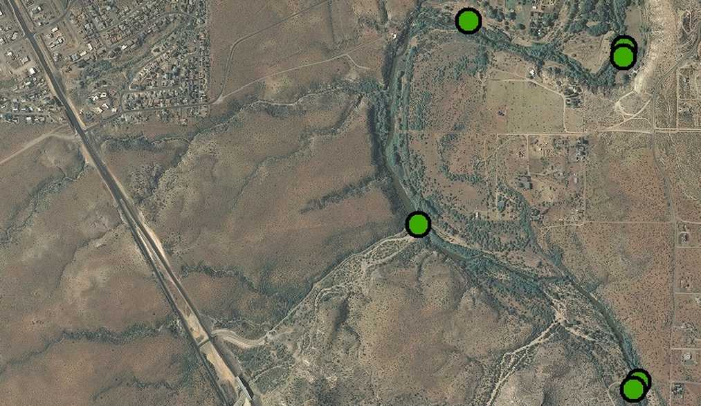
The shoreline area on river right becomes a tall limestone bluff less than a half mile below Bignotti.  As the river bends to the left here, the channel has a large island.  Most of the stream flow is passing to river right at the bottom of the undercut bluff.  Our primary rule of paddling is "go where you can see a clear channel."  Unfortunately, we could not see a clear channel to river right.  We also realized that there would be no boatable channel on river left.  After some discussion, we decided to violate our primary rule above.  Why?

I reasoned that this portion of the river is run by a commercial outfitter who takes total novice boaters on the "Water to Wine Tour."  As noted, we had observed a group of such boaters on our last trip.  I reasoned that, although we could not see a clear channel one must exist because it would be illogical for a commercial outfitter to subject novices to dire circumstances.  Luckily, this logic was correct and we did not encounter any impassable strainers in the right hand channel.  There are a couple of maneuvers that are moderately tricky for canoers but nothing impossible. It's actually quite a challenging and scenic run there at the base of the undercut bluff.  No far below this area, we observed the take-out for the Alcantara Winery.  There is a prominent "No Trespassing" sign with the winery's logo affixed.

The stretch below the winery has numerous tree obstacles but none are particularly hazardous.  All require vigorous and well executed paddling strokes to avoid.  The limestone bluff soon switches from river right to river left.  This bluff becomes more clifflike and it quite striking.  Many large blocks have fallen off this small cliff and lodged in the river channel.  It is a short but very beautiful stretch of river.  Astute maneuvering continues to be required in this area.

The cliff on river left ends abruptly at the Oak Creek confluence on river left.  This is a wonderfully beautiful area and we regretted not having enough time to stop and soak up the beauty.  Not far below the confluence is a spot called "Sheep Crossing."  In the not too distant past, large herds of sheep were driven across the river here.  The large area on river right was a popular public destination until it was developed as a major membership-only RV campground known as Thousand Trails.  There is a remnant of public access next to the fence line for the RV development.  However, it would be a long and arduous carry from the parking area to the river.  It is mostly used by fishermen and sightseers now.

The area below the Sheep Crossing is one giant lake.  In acreage this still water lakelike area probably is larger than many of what Arizonans consider to be actual lakes.  I joked with Joshua that it is clearly big enough to support numerous jet skis.  I've often thought that a skilled wind surfer could have a blast on this lake.

The reason for the lake is simple enough: there's a large diversion dam on the downstream end of the lake.  It is one of the largest diversion dams on the river, ranking behind only the Cottonwood and Verde Ditch diversions.  It's definitely larger than Diamond S.  Water drawn from the river here goes into a ditch system on river left and is the primary irrigation water for ag lands on the Yavapai-Apache Nation Reservation.

We scouted the entire dam from the ditch inlet on river left all the way across the face of the dame to far river right.  We scouted both from the canoe and on foot below the dam itself.  We concluded the only safe portage would be far river right.  The portage here is not too complex but care should be exercised because of rough rocks, surfaces and even a large 2-inch diameter woven wire cable.  After the portage, one must push the canoe through two small, shallow channels to reach water deep enough to paddle.  As diversion dams go, this is a relatively easy portage once you know where the portage is actually located.  Any portage at higher flows could be far more problematic that the low flow we enjoyed.

The area below this dam is very beautiful. The riparian areas from the dam to Newton Lane appear to have fully recovered from the devastating 1980's and 1990's 100-year floods.  There is a substantial willow gallery forest-in-the-making on both sides of the river.  At one point, we stopped to scout a cluster of willows that had become established in the middle of the river.  Although perhaps technically "runnable," we decided to be prudent and error on the side of safety.  The portage was very easy as we simply towed the boat over some native reeds.  At higher flows, the area of the reeds would present a clean run of this spot.

The channel in this area is mostly wide open and free of obstructions.  It is very beautiful even in leafless wintertime.  We were surprised to find a significant obstruction at the confluence of Hayfield Draw.  Naturally, there is a large alluvial fan at Hayfield Draw and it makes a nice pull out.  Several willows on river left have bent down over the river.  The trunks of two willows are low enough to make passage nearly impossible.  The branches of the other willows create quite a thicket.  At first we thought we would have to portage by carrying the boat around these trees.  However, after careful study, we discerned a lining route through the trees.  By wading carefully through the vegetation, we were able to get the boat around this area in short order.

Once again, the channel opens up and we marveled at the beauty of the native riparian species and the lack of invasive reeds and tamarisks.  It's very beautiful stretch of river and only a handful of structures are noticeable.

While enjoying ourselves in this area we paddled to a complete dead end.  The river simply stopped.  Thinking we had missed a channel, we paddled far back up into the still pool.  No channel.  No river.  All of the river flow simply filtered left through a dense, thick, debris-clogged native willow forest.  We could see no hint of any channel even half as wide as a canoe.  We paddled down to the far end of the pool here and got out to scout.

We walked down about halfway through the lateral thickness of the forest.  We'd estimate that its width ranged from 50 to 150 feet.  I waded out as far as I dared into the forest and could see no hint of anything resembling a lining route, let alone a paddle-capable route.  Finally, we walked to the downstream side of this forest, thinking that this would be where we would put the boat back in after portaging.  However, we looked farther downstream and were chagrined to see a river-wide willow fence of mature trees which had in turn collected the usual assortment of natural and man made detritus.  We trudged down to see the scope and extent of this obstacle.  It was then that we realized we had a very long and arduous portage ahead.  We didn't measure it but we think it was at least 200 yards and maybe as long as 300 yards.  Luckily, there was a clear route across a large alluvial fan that had been discharged from a dry wash on river right.  About two-thirds of the portage route was sand and gravel and about one third was medium size cobbles and some larger rocks.

We each used a 15-foot NRS strap to loop through the front grab handle of the canoe.  We made shoulder harnesses and evenly distributed the weight of the boat as we towed it on the long portage.  This type of a portage is very hard on the hull of a canoe.  Luckily, the Mad River Explorer is built to take this type of hard usage.

The re-entry to the river below these obstacles is very tricky so we turned the canoe stern first to give Joshua more room to kneel in the boat.  Also, in this configuration, the canoe turns much more quickly (even if it is tippier) and we were able to make the correct moves to reach safe water once again.

Most of the river channel below this point is clean and clear.  There are a few strainers here and there that require much attention and careful maneuvering.  One was so tight we had to actually use the tree branches themselves to pull our way through the tiny slot.  Luckily, at this spot, there is no real current to worry about pinning the canoe onto the tree.

There is another smaller diversion dam that requires a very short and easy portage. The last time I paddled this stretch of river was in March 2007.  The flow was roughly about the same as we experienced yesterday.  However, I did not recall much about a particular spot.  After we finished the short portage at the small dam, I noticed signs of whitewater ahead.  We donned our helmets and I then remembered that there is actually a genuine bedrock rapid located here.  The Verde River flows directly over a large area of eroded Verde Limestone.  The rapid has three sections.  The very first might be a Class One.  The second is definitely a Class One and the third and final drop is easily a Class Two.  At yesterday's flow, it's possible some canoers might rank it as a tough Class Two or even a Three (for canoes). Note that for an inflatable kayak it would be a real easy Class Two, maybe even just a Class One. (See commentary)

We were quite lucky to get through the lower drop upright and dry.  The canoe hit a portion of the bedrock and turned sideways as it approached the small wannabe keeper wave and possible wrap rock at the bottom.  Luckily, we both made the correct strokes and paddle braces to avoid being flipped here.

There is a dry wash on river right not far above Newton Lane.  At some point within the past year or two, a summer monsoon discharge dumped a large alluvial fan into the river.  We suspect that this fan at one time extended the full width of the river.  We suspect that a subsequent higher flow eventually carved out a channel on river left. It's quite rocky but makes for an exciting and fun ride.  It doesn't deserve a rating as a genuine rapid but it sure is a notable riffle.

We had hoped to arrive at Newton Lane at 3 pm but arrived instead at 3:15 pm.  As usual the Newton Lane RAP road is in marginal condition best suited to high clearance (and maybe even 4x4) vehicles.  Luckily, our little Nissan was able to climb up the slippery slope with only minimal loss of traction.  The passengers were forced to walk this slope.  Their extra weight would have probably changed the outcome of our exist from this area.  (See commentary.)

We consider this stretch to be the most natural and scenic stretch of the river in the entire Verde Valley between Tuzigoot Bridge and Beasley Flats.  Why?  Here are the reasons: 1) Condition of natural riparian areas; 2) Scenic beauty of bluffs, cliffs and other natural features; 3) Challenging water features; 4) Expansive Beauty of natural river channel ; and 5) Lack of visible man-made features.  As the native riparian species have grown in size, so have they shielded from view many of the previously visible man-made features.  Compared to other stretches of the Verde inside the valley, there are negligible visual impacts from man-made features.  Due to the mandatory portages and long distance between public river access points, it is likely that this stretch will never receive much usage and paddlers will therefore be unlikely to encounter other boaters.

I think I've forgotten a portage in there someplace.  I will review the digital voice notes and make amendments as needed.  This is a first draft completed at 12:30 pm, February 8.  As amendments are made, we will note their date and time.

Cheers, jp

February 7, 2011

2nd Field Trip: Bignotti to Newton Lane

Today's plan is to paddle from Bignotti to at least Newton Lane.  (See RAP MAP below.)  If we get an early start, we might try to make I-17.  If we are way ahead of schedule we will strive for the Camp Verde Black Bridge (AKA: Rezzonico Park).

Our water continues to be much below normal and barely above the record minimums for this date.  The Verde at Clarkdale is running 79 cfs and the minimum is 74 recorded in 1972.  Oak Creek is running 44 cfs at Cornville and the minimum was 29 in 1963.

Interestingly, 1963 must have been VERY dry.  We checked the Cottonwood historical climate records this morning.  The first 8 days of February in 1963 were all  consecutive record setters, ranging from 76 to 87 degrees. Today back in 1963 is was 83 degrees!

Our weather today looks to offer calm conditions with a high near the long-term average for this date: 64 degrees.  Chances are it will be in the upper 50's when we put on the river and the lower 60's when we take off.  Except for the low water, this is an ideal early February paddling day.

We still will be using the Arizona State Parks Mad River Explorer.  We have, however, obtained two much more suitable life jackets, a large dry bag and two helmets from the Verde NRCD.  Helmets?  Why?  The helmets are for trees.  If we attempt to run past a tree today, we're going to don the helmets just in case we misjudge the run and get tangled up in the tree.  Most river strainers have a lot of broken, sharp, stubby branch remnants sticking out from their trunk.  These things can wreck havoc with a human scalp!

Joshua Wheeler and John Parsons will once again be paddling partners.  We've returned Max Castillo's old Garmin and will only be using the Garmin 60Csx.  We're taking a back up digital camera in case our pocket model dies (as it almost did the first trip).  We think we will have a much better rig set up for the canoe this time around.  As anyone who runs rivers well knows, each trip rigging is slightly different than any other trip.

One of our goals on this trip is to obtain much better photo documentation of the Bignotti RAP.  We will also spend some time scouting the best route from the parking lot to the river as well as the best landing spot.  We will take some survey flagging to mark the route and beach.  We might even take a couple of bow saws, pruners and loping shears to do some "trail maintenance."

We will be giving Joshua some pre-trip paddling lessons and additional safety instructions today.  We might even engage in some pre-trip warm up stretching exercises and light calisthenics.

That's the plan, we'll see how it works.

Cheers, jp

February 3, 2011

Verde River RAPs

Above you can see all of the various River Access Points (RAPs) on the Verde River from the Highway 89A bridge at Cottonwood (Bridgeport) all the way to Beasley Flats below Camp Verde.
Almost all of these RAPs are public.  Two are not actually public: The YAN RAP (YAN = Yavapai Apache Nation) and the I-17 RAP.  This map was prepared for general perspective.  We will soon attempt to estimate the distances between each RAP as well as the overall total distance of the project length from Bridgeport to Beasley.  Click here for the interactive RAP Map.

Bridgeport to Bignotti Photos


Above is an album of 53 photos from the trip. It required A Flash player to work. If it doesn't load, click here to see the album photos one-by-one.

February 1, 2011

Three Cheers for The US NRCS

Perhaps the most vexing issue of this project is how to get GPS data out of the Garmin and into GIS-compatible files.  Max Castillo at Dead Horse knows how to do this but he is very busy.  Also, since this project isn't directly under his supervision, we are hesitant to prevail on his time and skills.
On January 21, we participated in the Verde NRCD "Wine Tour" to discuss various conservation programs with local vineyard managers.  Three of the participants were US NRCS Staff from Flagstaff and Phoenix.  We discussed our Garmin to GIS issues with Dino DeSimone.  He pointed us to a computer program from the Minnesota DNR.  Inititally, we misunderstood and thought we needed to have a GIS progam installed to be able to use the DNR program.  Today, we learned otherwise.  Dino explained that the purpose of the DNR program was simply to extract and convert Garmin GPS data into GIS-compatible format(s).

We then downloaded and installed the program and were easily able to put the Garmin data into GIS file formats.  We emailed the files to Dino at the US NRCS Phoenix State Office.  He was quickly and easily able to load the data onto a photo-ortho GIS map shown above.  He emailed back the JPG as a 5 meg file.  We reduced it to a 118KB file for this blog post.  We also did a clip of the large file to shown enlarged details (below).  It is a 91KB file.

We called Chip Norton twice to excitedly pass along the good news.  This is a huge breakthrough--not only for this project but for all sorts of future volunteer efforts on behalf of FOVRG and its sister organizations as well.  This is one of the more exciting days we've ever enjoyed with regards to making useful and effective strides forward in technology usage!

That's why we've entitled this blog post "Three Cheers for the US NRCS" and especially Dino DeSimone.  The NRCS Staff is always so helpful and a delight to work with.  They have always been "there" to help their partners, associates and those involved in the field of natural resources conservation.  THANK YOU, DINO, and THANK YOU NRCS!!!!!!